
Pierre Charles L’Enfant, the man credited with designing Washington, is buried among the United States’ most revered on a prominent hill in Arlington Cemetery, overlooking the city he conceived. His impressive burial plot--positioned just above John F. Kennedy’s eternal flame and in the shadow of Robert E. Lee’s Arlington House--belies his ignominious twilight years, which he spent living destitute on the outskirts of the project he envisioned but was prevented from seeing through to completion. When he died in 1825 in Prince George’s County, Maryland, in the home of a family who had taken him in, L’Enfant had little more to show for a life devoted to engineering, architecture, and urban planning than a few surveying tools and other possessions worth approximately $46.
Today we remember L’Enfant as the visionary who designed the national capital (or maybe even just the person after whom L’Enfant Plaza was named). Indeed, the inscription on his grave in Arlington, which first appeared when his remains were transferred there in 1902 from an inauspicious grave in Maryland, simply states that he was responsible for designing the Federal City under the direction of George Washington.
While “L’Enfant’s City” (the area between Florida Avenue and the Potomac, and bounded by the Anacostia in the east and Rock Creek Park in the west) largely resembles how the architect originally conceived of the area, L’Enfant only worked on the project for about a year. In designing the Federal City, L’Enfant displayed his usual penchant for the extravagant and exhibited an uncompromising nature that put him at odds with his direct superiors. His propensity to eliminate any obstacles in the drive to realize his grandiose vision (including entirely razing buildings that encroached on yet-to-be-built avenues) and his insistence that the city be realized as a whole rather than piecemeal eventually forced him from the project. L’Enfant’s imposing vision for a Federal City on the Potomac--what he prophesied would be the heart of a continental empire--outpaced the finances, patience, and political ambition of the still nascent republic. The tempestuous nature of L'Enfant's stint as chief designer of Washington was repeated throughout the rest of his career, forcing him to lurch from one unfinished project to the next.
Certainly, L’Enfant’s vision for the capital significantly influenced its final look and shape (as well as its specific location), but the actual plan that was engraved and utilized to build the city was one that Andrew Ellicott, geographer general of the United States, altered and changed without L’Enfant’s knowledge or consent. In his final days, after a handful of British invaders sacked the city in 1814, L’Enfant often roamed the uninhabited spaces of “his” capital city, traversing the empty, broad avenues that he conjured up two decades prior, “deploring the slightest deviation from his original design," as French diplomat Jean Jules Jusserand later wrote.
As the city grew throughout the course of the 19th century, little heed was paid to L’Enfant’s original plan. It wasn’t until the turn of the 20th century, in the midst of the City Beautiful movement, when interest in L’Enfant’s original vision for the city was revived. In January 1902, a Senate committee examining the improvement and development of Washington concluded that “The original plan of the city of Washington, having stood the test of a century, has met universal approval. The departures from that plan are to be regretted, and wherever possible, remedied.” Shortly thereafter, L’Enfant was reinterred in Arlington Cemetery, and the planner who died nearly penniless and in obscurity achieved the near-mythical status he had sought but failed to obtain.
L’Enfant’s fall from grace is largely forgotten today. What remains of the L’Enfant legend are mostly tales that sprung up following his death. Some of the more widespread include the notion that the city’s broad avenues and several circles and plazas were designed to better defend against invading armies or that they came about after the planner’s beer glass left several rings on his unfinished sketches. Another holds that he designed the city with no “J Street” because of his feud with the first Supreme Court Chief Justice, John Jay, and that Benjamin Banneker, the free African-American who helped survey the boundaries of the Federal District for a few months in 1791, recreated L’Enfant’s map from memory after the architect refused to hand over the plans around the time of his dismissal in early 1792.
While folktales are generally innocuous and perpetuated with no harm in mind, their usefulness as a means of communicating the past is insufficient. The mission of this blog, therefore, is simple: investigate the past and bring to light the history that we encounter daily in and around the District of Columbia.
By doing so, Colleen, Andrew, and I (and, anyone else inspired by our mission) hope to give Washingtonians a better understanding and greater appreciation for a city that is largely regarded with antipathy beyond (and, sadly, within) the Beltway. With former Supreme Court Justice David Souter’s disparaging remarks in mind (he recently described Washington as “the worst city in the world,” and once likened living here to "an intellectual lobotomy”) we set out not necessarily to add to the historical record, but to instead to make it more accessible and better understood.
“Excelsior!”
 Pierre Charles L'Enfant is one step closer to being memorialized in the US Capitol's Statuary Hall. The House of Representatives on 16 December passed a bill introduced by District of Columbia Delegate Eleanor Holmes Norton that would allow DC to place a statue of a prominent District resident in the hall, an honor usually reserved for the states.
 Gordon Kray's L'Enfant statue at 1 Judiciary Square
 The statue's profile appears to adhere closely to the only known contemproary likeness of L'Enfant, which was a silhouette executed by Sara DeHart in 1785 and today hangs in the Diplomatic Reception Room at the State Department. Attached to L'Enfant's lapel is a medallion denoting his membership in the Society of the Cincinnati, an organization whose membership was limited to officers who had served at least three years in the Continental Army or Navy. L'Enfant designed the society's medallion in the early 1780's.
 A compass in L'Enfant's hand
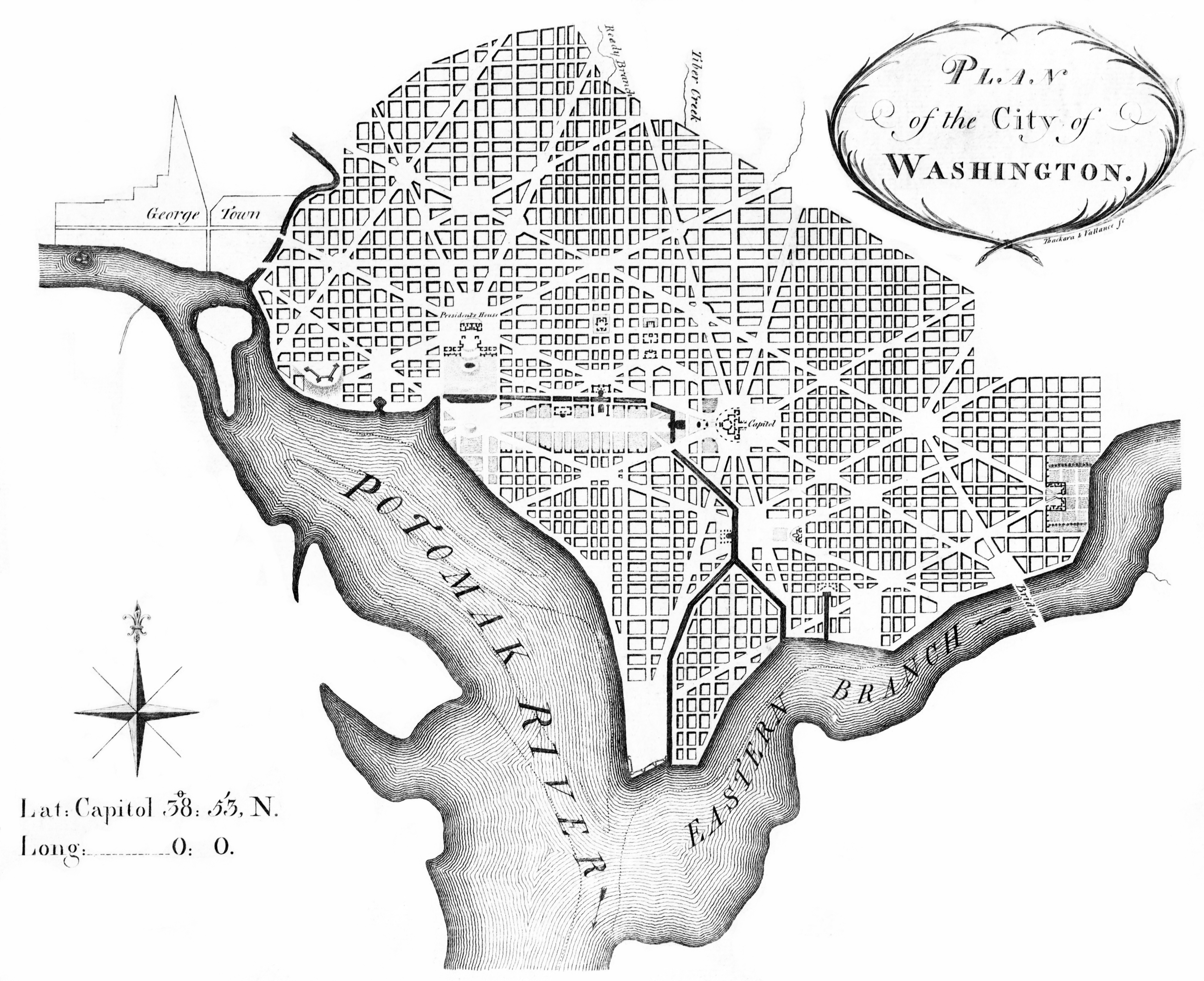
 Oddly enough, the map in L'Enfant's hand does not appear to be his plan for the city, but the one Andrew Ellicott slightly altered and engraved after L'Enfant's dismissal from the federal city project in 1792. (note the similarities between the title of this map and the Ellicott version found here)


